1F, 112 Oosai, Sai-Village, Aomori 039-4711
Phone 0175-38-4515
FAX 0175-38-4514
About Sai Village
Location
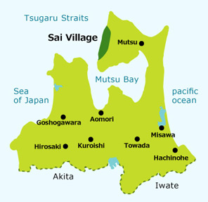
Sai Village is located at the western side of Shimokita Peninsula, and narrow rectangle in shape with the north-south shore along Tsugaru Straits as the base.
Shimokita Peninsula is also known as Broad Axe Peninsula, and Sai Village is located at the blade.
It shares the northern border with Oma Town and the eastern/southern borders with Mutsu City, and faces Oshima Region of Hokkaido across Tsugaru Straits.
Geographically, it is mostly comprised of steep hills with little flat land, i.e. most of the village is in the mountains.
In Sai Area where the municipality office is, its southern neighbor of Yagoshi Area and more southern parts of the village, the mountains stand right by the shoreline, forming the sheer cliff.
This leaves very little field for farming. We indeed have only small farm land in Harada Area and Nodai Basin.
Villagers live in scattered settlements – eight along the shoreline and one in the mountain.
Natural Environment
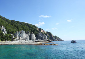
Sai Village is 28km long from the north to the south and 14km wide from the east to the west, with the vast 135km2 in space, and has abundant natural tourist attraction such as “Hotokegaura” - a part of Shimokita Peninsula Quasi-National Park, “Gankakeiwa Rocks”, and “Nuidoishiyama”.
Also, the geographical feature of the village is precipitous, surrounded by the sea and mountains and with the beautiful shoreline. It is blessed with rich natural environment with the colorful seasonal changes, presenting a peaceful scenery.
Climate
The climate of Sai Village is influenced by the warm Tsushima Current, and is often covered by low-pressure system despite the high latitude.
The north-west wind blows hard especially during the winter and spring, promoting the salt pollution and wind hazards.
The annual average temperature is 11.3 Centigrade with the peak in August and the steep drop at the end of September. It goes down further in October and November.
The rainfall is largest in April and July, and lowest in March.
The annual rainfall is around 800mm, and the deepest snow cover is around 60cm. There is little snowfall along the shoreline due to the northwest monsoon, but the mountain side forms snow drift, causing deep snow cover.
